
Personal Weather Station (PWS) Owner Features
A series of vignettes for Weather Underground to illustrate why a forecast matters to a variety of different people
Ken Larsen and Jerry Mader, Cattle Herders (Rapid City, S.D.)
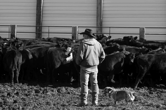
Ken Larsen, formerly of Stolen Kiss Ranch, and Jerry Mader of Jerry Mader Ranch know a thing or two about managing a cattle herd. Although he’s too modest to admit it, Jerry has a reputation beef cattle herd, meaning he is known for raising quality cattle and is likely to be one of the top sellers at market. When managing a herd of 500 mother cows (not to mention around 500 calves and of course the bulls needed to produce said calves) on 17,000 acres of land, Jerry and Ken have to keep a close watch on the weather.
First, there is the matter of maintaining a herd. If the area is heading towards a drought, Ken and Jerry know there isn’t going to be enough water and grass for all the cattle. Here they might think about selling off some of the herd so they don’t stress the land. On the other hand, if it looks like particularly wet conditions are around the corner, building up the herd might be the way to go.
Then there is the physical well being of the cattle. Unlike a dairy cattle herds, which are kept mostly in barns where they are milked twice a day, Jerry’s beef cattle herd have never seen the inside of any barn or building. Since the herd is outside 365 days a year, Jerry and Ken have to make sure they are in the best area at the time. If a storm is moving in, they might move the cattle to rougher country until the storm lets up and they can be moved back to open flat ground.
What can be the most dangerous, however, is moisture. In October, 2013, heavy rain and snow fell on South Dakota for nearly four days straight. Many cattle herders in the area lost substantial numbers of cattle, most of which drowned. Ken and Jerry explain that the cattle didn’t necessarily drown in the dams that filled with water, but conditions made it so they ingested copious amounts of snow and moisture until they finally drowned. With 100% humidity and a driving snow they couldn’t escape from, the cattle sucked in a lot of liquid and filled their lungs.
The cattle act differently depending on the weather too. When a storm starts coming in, the cow’s instinct tells them they may not be able to eat for a couple of days. Temperature is dropping, pressure is low and snow starts coming in, so the cows eat everything but the barbed wire fence. Ken and Jerry also see a difference in their cattle when the barometric pressure is changing, either extremely high or extremely low. Spring calving also tends to increase two or three days after a pressure system passes.
Ken and Jerry drive the herd, which is separated into several smaller herds spread out across the land, on horseback. And while temperature, whether it is very hot or very cold, might make them uncomfortable (and probably a bit grouchy), it doesn’t affect how they manage the herd. Rain, snow and dense fog also don’t change their plans too much, but wind can change everything.
The cattle are less well behaved when there is wind, driven by the direction of the wind. The cattle walk with the wind in the hopes of finding better conditions. If a pressure system is moving in a counterclockwise fashion, the cattle can usually be found making their way from the west to the southwest to the south to the southeast and so on until the winds finally die down. That is, until summer. When it gets hot out, the cows walk into the wind in the hopes of getting those pesky flies off their shoulders.
Bil Grauel, Fire Ecologist (Boise, Idaho)
All firefighters learn about the three major components of fire behavior: fuel, topography and weather. Fuel and topography are more or less static whereas weather is the most uncertain and dynamic of the three. It’s because of this disparity that Bil Grauel, a Fire Ecologist and Burn Boss, pays special attention to meteorology.
As a Burn Boss, a specific classification for those trained in prescribed wildland fires, Bil is always in tune with the diurnal cycles of temperature, relative humidity and wind as they affect fire behavior. He studies weather data carefully in order to safely recommend a prescribed fire - the burning of specific areas in order to achieve some objective, such as hazardous fuel reduction (meaning they need to burn off all the little sticks, twigs and shrubs that can cause catastrophic wildfires when not managed).
His official title, however, is “Fire Ecologist,” which puts him in charge of predicting fire behavior (i.e. how fast it will burn, where it will spread, which way the smoke will blow, etc.). His ability to predict the behavior of the flames, based on his assessment of those three main wildfire components, allow him to make the best plan for a safe prescribed burn.
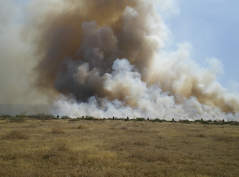
Wind speed and direction are possibly two of the most important weather factors. Wind speeds, of course, help Bil predict how fast a fire will burn, while the direction tells him not only which direction the fire will spread, but also where and possibly how far the smoke will drift. In addition to knowing this hard weather data, Bil also has to study the local topography to determine how that very localized terrain might affect general winds. Relative humidity is another important component as it controls the moisture contained in “fine fuels” - things like pine needles, grass or leaf litter that are often carriers of fire when not too damp.
Bil’s Rx for a necessary, contained fire, often comes with weather restrictions. A fire may be prescribed with the caveat that it can only be completed on a day with a southern wind direction in order to blow smoke away from a town to the north. Pine forests may be prescribed in late fall or early spring, ensuring that it won’t be too hot for the fire to get out of control, but still warm enough for the woody fuels (i.e. sticks and branches) will be dry enough to burn.
On the other hand, Bil notes that when burning brush, chaparral or other places that have historically evolved with high intensity fires, burns are usually prescribed in June when it’s extremely hot and dry and there is enough wind speed to allow for a high intensity fire to achieve the needed objectives.
Bil maintains a membership to the American Meteorology Society to keep up with his admitted “obsession” with the weather and uses his personal weather station to stay in tune with daily weather systems even when not working. Once at work, he builds on his knowledge while using sophisticated software, both spatial and non-spatial, to input weather, fuel and moisture variables and come up with predicted fire behavior.
“I don’t know how to describe it,” Bil says. “Firefighters are interested in weather in general, but once you become a Burn Boss and you’re responsible for laying fire down on the ground, believe me, you get much more interested….it’s just critical to know as much about weather and weather forecasting to generate desired fire behavior and ignite prescribed fire safely.”
Eric Nickerson, Hot Air Balloon Pilot (Milford, N.H.)
When Eric Nickerson takes flight in his 90,000 cubic foot hot air balloon, he needs to be aware of the local conditions to ensure a safe and pleasant ride. Wind is always on Eric’s mind before, during and after flight. He needs low winds on the grounds for a proper takeoff (and later a good landing). He prefers winds on the ground to be around 1 to 7mph, while at 3,000 feet in the air he likes winds less than 20mph.
Instead of a steering wheel, hot air balloon pilots like Eric steer by using propane burners. Hot air rises, meaning the more a pilot heats the air within the balloon, the higher the balloon will rise. Eric’s ability to steer his balloon is based on this altitude to either climb or descend into winds going different directions, hence why his knowledge of the current wind conditions is so important.
Kole Kellen, Volunteer Firefighter (Sublette, Ill.)

The Kellen family has a combined 300 years of service in the Sublette Fire Department, protecting the 450 residents of Sublette, Illinois. As a volunteer firefighter for the past 11 years, Kole raised the bar for department preparedness when he loaded the data from his personal weather station to the fire department’s command center. With every call, the firefighters take a glance at Kole’s PWS dashboard.
For an ambulance call, a quick glance at temperature tells them if the patient may have hypothermia. When a fire starts, wind direction and speed help Sublette firefighters determine what structures and fields are at risk of burning. Wind data can even help them determine when to call for backup when a dry grass field catches fire during strong wind conditions. Even in the rare event of a hazardous material incident, PWS data helps Kole and his team determine where the poisonous fumes are drifting, allowing them to approach from a direction that won’t put them in danger.
David Stanley, Part of the Stanburn Winery Family (Stuart, Va.)
Grapes like it dry. They like getting stressed out. Those growing the grapes probably like the stress a little less. Depending on the time of year, David Stanley and the rest of the Stanburn Winery family, watch the weather to track cold snaps, humidity levels, temperature and pressure. Depending on the time of year, this vineyard, planted in 1999, looks at a number of weather conditions when managing the vines.
Frost can be deadly this vineyard, originally planted in 1999. Bud break (when buds are coming in and leaves are sprouting) is a time when grapes are particularly susceptible to frost, which can wipe out the entire crop for the year, or even kill the vine entirely. As the berries enlarge and the clusters start to close off, humidity becomes a bigger issue. When the sky is overcast, there is light rain, not a lot of sunshine and plenty of humidity, the possibility of mold and mildew increases drastically.
David watches the humidity levels to see what treatments or precautions need to be taken. Typically the taste and pH of the grapes determine when to harvest, but since Stanburn sits on the East Coast, harvest season is also hurricane season. When it’s clear the grapes can’t hold up against an oncoming hurricane, David and his team may have to pick before the storm comes in. Overall, sunny days and cool nights are ideal for harvesting as the cool nights lock in that taste chemistry!
Pro tip: David’s favorite wine is their Vidal Blanc, so if you’re into white wines, then wine not?

Liverpool Public Library, resource center for Liverpool residents (Liverpool, N.Y.)

If you don’t already have a library card, you should get one (Pro Tip: September is National Library Card Sign-Up Month). And if you’re thinking libraries are dingy caves where old books gather dust, then think again. Libraries across the nation have installed personal weather stations (PWS) and connected them to Weather Underground's PWS Network in order to provide free weather data for nearby residents. One such library is the Liverpool Public Library, located in Liverpool, New York.
The Liverpool Public Library is not just a book depository. They believe all public libraries should fill an important niche by providing in-depth resources for the local community. In Liverpool, a village located just 10 minutes from downtown Syracuse, you can visit the public library to browse local maps, historical photos, demographic information and terrain data (i.e. the village sits at 420 feet of elevation).
The library’s website has links to Liverpool-specific information, such as a video series on the history of the village, ancestral and family history records, licensed business directories, local ordinances, information on disability access, printed and digital media, community job boards and even a local coffee quotient (a measure of the number of Starbucks stores per 10,000 people). The library itself is equipped with WiFi, wireless printing (you can print
from your phone), free photo scanning through their Kodak Picture Saver Scanning System, meeting rooms available for non-profit organizations and computer help from Mr. G, the tech guru. You can even apply for a passport or renew your old one.
Staff at the Liverpool Public Library like to focus on what is local, providing niche resources for Liverpool residents looking for information - information like the day’s hyperlocal forecast. That’s where the weather station comes in. Like many places across the U.S. and around the globe, weather forecasts were never very specific or accurate for the hyperlocal weather in Liverpool. By adding a PWS to their roof, the library was able to vastly improve forecasts and provide important weather data for the members of the Liverpool community.
The weather data page, which includes a webcam, is one of the most heavily trafficked pages of the library’s website. Staff members regularly consult the station’s forecast during lunch hours - is it nice enough to walk to the café down the road or should they stick as close as possible because it’s pouring buckets outside? Patrons of the library frequently check the PWS, as well as the webcam, in large part to see the road conditions. Liverpool is a particularly snowy village in the winters, making road conditions a constant topic of concern. Former residents of Liverpool, some of whom have long since moved away, still check the library’s PWS to connect with the village and see what is happening in their former community.
Liverpool Public Library’s motto is “Where the Community Connects.” By providing a community gathering place and disseminating important local information, not least of which is a hyperlocal forecast, they truly do provide a community connection.
Liverpool Public Library is also on every social media channel you could hope for, so check out their Twitter, Facebook, Tumblr, Pinterest and Instagram accounts! And remember, September is National Library Card Sign-Up Month, so find a library near you, get your library card and tell them to install a PWS (if they don’t already have one, that is)!
Southern Illinois University (SIU) Physical Plant Services (Carbondale, Ill.)
With about 17,000 students, Southern Illinois University (SIU) is classified as a Carnegie Foundation High Research Activity Institution and is ranked among the top 4% of higher education research institutions in the U.S.
Located about 5 ½ hours south of Chicago, at the very bottom tip of Illinois, SIU sits on 4,000 acres of land with approximately 7.5 million square footage of housing and academic structures. While students, researchers and professors alike focus on maintaining and building up their knowledge base, the SIU Physical Plant (that’s their facilities division) - with the help of a personal weather station (PWS) of course - works on maintaining the grounds.
Brad Dillard, Associate Director of Facilities, explains that he and his team look at all climatological conditions on a daily basis for a myriad of different reasons. By seeing what is happening now and what weather conditions will be happening next, they can make better management decisions and continue to maintain the campus to the best of their abilities.
New construction, lawn mowing, snow removal, insecticide spraying, mail delivery services, power plant operations, printing and duplicating services - all such functionalities and more are provided by the Physical Plant, or facilities division. By installing a PWS on top of the Physical Plant’s main office space, they are able to schedule their maintenance more efficiently around the weather. That way they aren’t spraying insecticides during a windstorm blowing towards student housing or trying to finish construction during torrential downpours.
SIU is located in a sort of ‘ice belt,’ so winters can be tough, especially from a maintenance perspective. The campus sees a great deal of freezing rain, wintry mix and sleet, not to mention good old fashioned snow. The maintenance crew has always used private weather forecasting data to assist in their snow removal process, but the PWS allows them supplement that data.
The official NOAA reporting station for Carbondale, Illinois lies at the campus airport, a good 4-5 miles northwest of the main campus. The airport is also surrounded by green pastures and a lot of land, whereas the campus has more asphalt and concrete. At this distance and with these changes in topography, there is often at least a temperature difference and even a few degrees difference means everything to those tasked with keeping people safe from snow and ice.
Their station also tracks solar UV radiation and evaporation rates. This helps them determine how much water their grass is going to lose or not lose in a day, so they can figure out how much they should water the lawn (or conversely, to turn off the sprinklers and save some water). This also helps them determine the best times to fertilize, plant and spray around the campus.
On Brad’s team is Chris Gaertner, Associate Director of IT, who also helps keep the PWS up and running. Although SIU does not have a meteorological degree, Brad and Chris often get calls from professors, researchers and department heads asking for access to the station’s data. Many use it either in their research or for background information in their lesson plans. SIU’s Department of Geography and Environmental Resources teaches climatological and meteorological classes and uses the data from the Physical Plant’s PWS to help students can gain an understanding of the hyperlocal climate they live in, allowing them to delve into a deeper understanding of the relationship between geography and weather.
Bill Hilton, Hilton Pond Center for Piedmont Natural History (York, S.C.)

It was 1982 when Dr. Bill Hilton Jr. made his family’s property in South Carolina a nonprofit nature center. The Hilton Pond Center for Piedmont Natural History explores all aspects of flora, fauna and natural history in Piedmont, a swath of land in the eastern U.S. that sits between the mountains and the coastal plain (it used to be the shoreline in prehistoric times when sea levels were higher).
Bill, now Executive Director of the center, has lived and worked on the property for going on 35 years. His special area of interest and expertise is birds, particularly ruby-throated hummingbirds. He studies the various birds that pass through his property and bands many of them to track migration, longevity and whether they have site fidelity to Hilton Pond (that means whether they stick around or come back to the same place or whether they are just flying through).
While many look at weather data to get a view into the future forecast, more often than not, Bill uses his personal weather station (PWS) and other weather data to help explain the past and present seasons. After recently looking at a two-week span of temperature, he noticed that one day was close to freezing. This happened to be around the time when several bird species were beginning to lay and incubate their eggs. The cold ambient temperatures made it hard for the birds to keep their eggs warm and as a result, these early-nesters suffered fairly substantial losses. Without weather data to look at, Bill says he would have a hard time explaining the unusual nest losses.
Bill doesn’t have to look at the numbers, however, to see the impact weather has on the nature center. Hilton Pond, whose water levels rise and fall with the rain or lack thereof, is a pretty accurate rain gauge in itself. There also was a large, 130-year-old white oak tree that towered over the entire 11-acre property. Its height made it a natural lightning rod when a thunderstorm rolled through one day. The lightning strike blew the bark off the tree and left it with a lightning scar. Bill says that was the beginning of the end of that tree, which fell down a few years later due to a severe rainstorm.
Although he hated to lose the tree, Bill was able to witness the full circle of life as the downed tree opened up a hole in the sky, which allowed more sunlight to the property and led to more herbaceous growth.
Bill’s “pet passion,” as he calls it, is phenology, the study of changing seasons and particularly how it impacts flora and fauna. South Carolina has four very distinct seasons, allowing Bill to clearly see the changes the land and its inhabitants go through during these periods. There isn’t a harsh winter, but a very hot summer. Spring and fall are both pretty short, which means greening after the last frost occurs very rapidly in spring and leaf color change is faster and shorter than that of fall in the mountains. Winters have a fair amount of rain, but less than 12 inches of snow - schools shut down in just 1 inch of snow. The leafless hardwood trees mean there is more direct solar radiation on the property, keeping it a little warmer than if there were pine trees that block out sunlight in the winter.
As a bird bander and long-time naturalist educator, Bill has banded more than 64,000 birds in 35 years, making Hilton Pond Center the most active bird banding station in the Carolinas. The most efficient way to catch birds is by far the mist nets. Imagine a giant 42 x 10 foot hair net strung up between two poles. The mesh is essentially invisible against the background, so birds fly into them and get caught. On sunny days, however, these nets become more visible so birds know to avoid them. When the wind picks up, the nets billow out and they lose the ability to catch birds. Bill also won’t run the nets when it rains. The caught birds can get their feathers matted down, which can be detrimental to them. Extremely hot days can also affect the bird’s health, so mist nets aren’t used then either.
Although these nets are the most effective means of capturing and banding birds, timing their use with the weather can obviously be a bit tricky, so Bill has a number of other traps for use in various weather.
In the wintertime, he focuses on what he calls his “real research” - looking at the ruby-throated hummingbird. They happen to be the most common hummingbird in the eastern U.S., where they breed in the summer before migrating to their winter habitats in Central America. Bill follows the ruby-throats down south, doing research in Costa Rica, Belize, Nicaragua and Guatemala.
With the weather station still at Hilton Pond, Bill can be anywhere in the world and pull up the weather data from back home. As a bonus, he has a webcam pointed straight at the center’s feeders, so he can monitor when they get low and tell his brother when to go fill them up again.
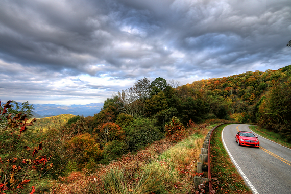
Ron and Nancy Johnson, Owners of TailoftheDragon.com (Robbinsville, N.C.)
Ron and Nancy Johnson have been riding the ‘Dragon’ since 1975. In 2000, they even set up TailoftheDragon.com to help fellow motorcycle and sports car tourists plan their trip to the Tail of the Dragon, also known as Deals Gap or simply the Dragon, a stretch of curved asphalt road considered by many to be one of the world’s best motorcycling roads.
If you’re a motorcycle novice, or simply a pro looking for a new place to ride, the Dragon is a pretty remarkable place. If you’re wondering what makes this road so unique, Ron and Nancy have stories that will have you wondering why you’ve never ridden the Dragon before, but it all boils down to a few main points. In the 14 miles that is considered “Deals Gap,” there are only two intersections: NC28 to Fontana Dam and a gravel road at Parsons Branch. Other than the Tail of the Dragon T-shirt Shack and the Deals Gap Motorcycle Resort, there aren’t any buildings in the area, and barely any evidence of human life within 20 miles in any given direction, so it’s ideal for a scenic ride. With 318 curves and little traffic - most of which is fellow motorcycle riders and sports car drivers - the Dragon is a huge attraction for riders looking for a thrill.
Ron and Nancy ride the Dragon twice a week when the weather is nice - but the trick is knowing when there will be good riding weather. That’s where the Tail of the Dragon personal weather station comes in. The couple uses their PWS and corresponding webcam to give visitors an inside look at what the weather will be like when they plan a visit to the Dragon.
The best riding days are typically in the summer, with lows in the high 60s and highs in the low 80s. It’s pretty rare for the Dragon to reach high 80s and above as it is situated in the mountains, but with the elevation changes that occur throughout the route, cooler temperatures are usually found by riding another 10 miles up the road to get to the mountaintop.
Ron and Nancy field hundreds of calls and emails a week from prospective visitors - many of which are asking about the weather. Although they never tell visitors if they should or should not go out due to weather - unless a blizzard or hurricane is rolling through - the couple does their best to provide all weather information that might be pertinent to their visitor’s rides. In these situations, they will pull up real- time data and give specific information, down to hourly forecasts.
“People don’t always know how to look at the weather predictions,” Ron says. “If someone pulls up a weather snapshot and sees that it’s going to rain all week, well that’s not going to happen. We may get an afternoon thunderstorm and in an hour it’s gone, but a lot of the weather reports just say rain, but it’s not all day. So that’s one thing we’ve really used...and what we tell our visitors. It’s just temporary.”
The hourly forecasts are the most important features for the couple, even when planning their own rides. Ron and Nancy will also make their visitors aware of things like wind and fog. Deals Gap is a forested area, so heavy winds can often litter the road with branches. Fog can also pose a problem at both the higher and lower elevations. Ron watches the radar to see if clouds are moving into the mountains, in which case visibility can drop drastically and it becomes like riding in “pea soup.” Around the lakes at lower elevations on the Dragon, fog can occur in the morning hours, but usually clears up by 9 or 10 a.m.
Snow showers and rain scare a lot of motorcycle riders off the road. It’s not a very pleasant ride, visibility can drop dramatically and the road can become very slippery. Ron notes, however, that cold is the main factor in motorcycle riding. “It’s difficult to ride a motorcycle when it’s under 50°F...most people have heated suites, but even then, it gets tough.” In addition to making it harder to operate a motorcycle, colder weather can make the asphalt pretty slick. Conditions like this make it difficult for many tame the beast...except for the Canadians, who have been known to ride the Dragon regardless of the weather!
Spyglass Condominiums on Lake Michigan (Holland, Mich.)

Residents of Spyglass, a 64-unit condominium association in Holland, Michigan don’t have much of a view. Unless, of course, you count the majestic Lake Michigan with it’s glistening shore and waves breaking down by the pier.
Standing on the shore by Spyglass, one can’t even see the end of Lake Michigan. That’s because it’s over 22,000 square miles in area. This large body of water has a pronounced influence on West Michigan’s weather, particularly on the town of Holland. (There is also Lake Macatawa, a smaller lake, only about 2.8 square miles in area, which sits directly behind the Spyglass condos and can also impact weather patterns.)
But because Spyglass is situated on a dune right at Lake Michigan’s shore, residents - not to mention those maintaining the condos - often deal with more significant weather concerns than their inland neighbors. In fact, weather on the shoreline was so different than the “official” Holland forecast coming from just a mile or two inland that around 1999, the residents of Spyglass decided to set up their own personal weather station (PWS).
They figured there had to be other people interested in the weather at the lakefront, so they soon connected their PWS to Weather Underground to share their weather information with the community. Now their station, and accompanying webcam, are used by boaters, fishermen, beachgoers, tourists and meteorologists on a daily basis.
Wind seems to be the biggest concern for all looking at the Spyglass PWS - for better or worse. Kitesurfers and sailboat owners monitor the winds to see when the best time is to get out on the lake. Residents of Spyglass monitor the wind particularly because of the potentially damaging winds that gain strength when crossing the lake.
These high pressured winds have nowhere to go when they hit shore except up, so they rip up the dunes, making it especially important for the condo association to constantly keep the windows and buildings in top shape so they don’t suffer any wind damage. (They’ve assured me, “So far, so good!”)
Even the 9-to-5ers stuck in an office all day monitor the wind at Spyglass. While they sit at their desks wishing they were outside, these workers pull up the webcam to watch the views along Holland State Park and see the waves lapping on the shore. The Spyglass PWS gets repeat viewers from all over the U.S., Canada, New Zealand, the U.K., India and Argentina.
“Spyglass is a very interesting and beautiful place to live,” says Sally Carr, resident of Spyglass Condominiums, “and being able to monitor the weather right on the lake shore is something everyone loves, whether they live here or far away. The weather station is something everyone loves!”